We went to the USGS (US Geological Survey) open house a week ago. The first thing we noticed was the sparse crowds. Hard to tell whether it was a lack of advertising or infelicitous scheduling as one scientist told us.
The best part of the open house is that the scientists-the lead investigators-are standing by their posters, eager to talk about the details and the implications. Janet and I talked for quite a while with a woman whose poster was about invasive species in the Sacramento delta and their effects on the levees. She was impressed by my story from Science News about an approach to controlling the zebra mussels but pointed out that it wouldn't work in open water.
She has been tracking the spread of the mitten crabs. They're a fresh water species, so the spread has been coming overland. A few miles at a time. Occasionally by intentional human intervention. The people trying to hold the crabs back currently have a line drawn, and seem to be holding it for now, though it's not clear how long it will last.
We also talked about the robustness and stability of the levee system in the delta. The delta is an unusual system, since it's a mix of fresh and salt water. The tides push the salt water in an out a certain distance every day. Above the level that the salt never reaches, but still within the delta, is where the aquaducts (which feed the central valley and LA) start. If the levees break above the aquaduct feeds, the increased water draw could pull salt water further up into the delta in a way that would be impossible (or at least horribly expensive) to repair.
The most surprising thing she told us was that the farm land behind the levees has subsided. (See the 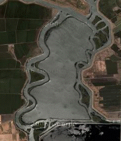 google or terraserver maps for a browsable view of the delta.) The land here was originally peat. As it has been farmed, it has gradually lost a lot of volume. When the levee system was built, the farmland was at or above the level of the river. The levees were built a few feet high to hold back the water. But the land has now subsided up to 20 feet in most places. (Janet and I drove through here, geocaching, on our way to visit her father a few years ago. We saw that the levees were much higher than the farmland, but didn't realize that the water was close to the top of the levees.)
When the levees break, the water rushes in, and can be infeasible to pump back out. Look at the satellite views again. The large areas the same gray as the river were inundated in the 80's, and after a short struggle, California gave up on trying to dry them out. The narrow green line surrounding the newmade lakes but inset from the edges are the old levees. Current worries are invasive species undermining the levees, general lack of maintenance, and the assurance that eventually there will be an earthquake.

No comments:
Post a Comment